Thursday, June 9, 2011

Cuba. Si!

Cuba. Si! – March 23 to 25, 2011

The alarm was set for 3:00 AM with the intention of pulling up the anchor and being on our way by 3:30. We had made our departure preparations (securing the dinghy, plotting our intended route, packing the ditch bag, etc.) the evening before. At 4:00 AM we left Spanish Wells Bay on Raccoon Cay with two other catamarans also headed for Cuba. With a ¾ moon overhead and the cool night breeze on our faces it really felt like we were off on another new adventure. 

Since our chart reader was still not functioning, the plotter would only display a stylized map of the world showing approximate locations of land masses and no depth soundings. We were about to venture into unfamiliar waters without the use of one of our electronic crutches. How did Christopher Columbus ever make it to America?

The banks west of the Ragged Islands are mostly un-surveyed and scattered with shallow coral. Our Explorer Chart Book has a single charted path with waypoints that we found to be reliable for our southward movement down the cays. From our anchorage at Raccoon Cay we headed for a point at approximately 22o 05’ N; 75o 55’ W, where we exited the banks and entered the deep water of the Old Bahama Channel.

 By 6:30 Am the eastern sky had lightened up and in the distance we could see the sails of the other two boats. By 8:00 AM the fishing competition had begun and we had three lines out. An hour later our travelling companions had already landed several mahi and a couple of barracuda. We had only managed to snag some weeds.
 
Eventually we did get a mahi too.

Most of the crossing was done in choppy, washing machine waves using full main and jib assisted by the engine in order to keep our speed around six knots. We wanted to time our arrival at Puerto de Vita, the only port of entry on that section of the coastline, in good daylight.  

 At noon we were able to make out land on the horizon. By mid afternoon we were approaching the coast of Cuba and could see the lighthouse marking the entrance to Bahia de Vita. 

We assumed that the Spanish voices we heard on the radio were Cuban officials trying to make contact with us. I used my rehearsed lines from our Spanish for Cruisers guide:
Aqui  velero Polar Pacer.”
“Bandera Canada”
I was not able to decipher the responses that came back at me but I now know that they were probably asking where we were arriving from and how many persons were on board. I was only able to answer with:  “Lo siento, no comprendo.” Eventually a heavily accented voice came on the radio telling us in English to “follow the little boat”.
Alexi, on the little boat, guided us through the marked channel and around the shoals into the well protected Bahia de Vita where we were instructed to anchor and wait until the officials could check us in to the country. 

The first person we needed to meet with was Dr. Ronaldo who was busy at the hospital. As it was already late afternoon, all six boats in the anchored in the bay had to wait until the next morning.  Shortly past 8 o’clock sharp Alexi arrived with the doctor on board his little boat. In order of arrival, each boat was visited to ensure that no communicable diseases were being introduced to the country. Anyone arriving from the Dominican Republic was given precautionary ant-cholera pills. Speaking very good English, Dr. Rolando asked us a few basic medical questions, checked that our refrigeration system was in good working order and had us fill out three forms. Soon we had our “Libre Platica”, the official document giving us permission to go to shore to finish clearing in.  After ferrying the doctor to the next boat in line, Alexi  came back to guide us into the marina and dock – med moor style – stern to the dock, bow anchor out in the channel and tied to a mooring ball on either side of the bows.
Five more officials came on board. The veterinarian checked for unacceptable meat and vegetable products. We had none. A customs officer collected information related to our boat, dinghy and GPS units. 

  A representative from the ministry of the Interior handled the immigration documents. He returned later with our passports and tourist visas. Although the visas indicated that they were only valid for 30 days we were advised that as Canadians, we would not need to renew them until 90 days.
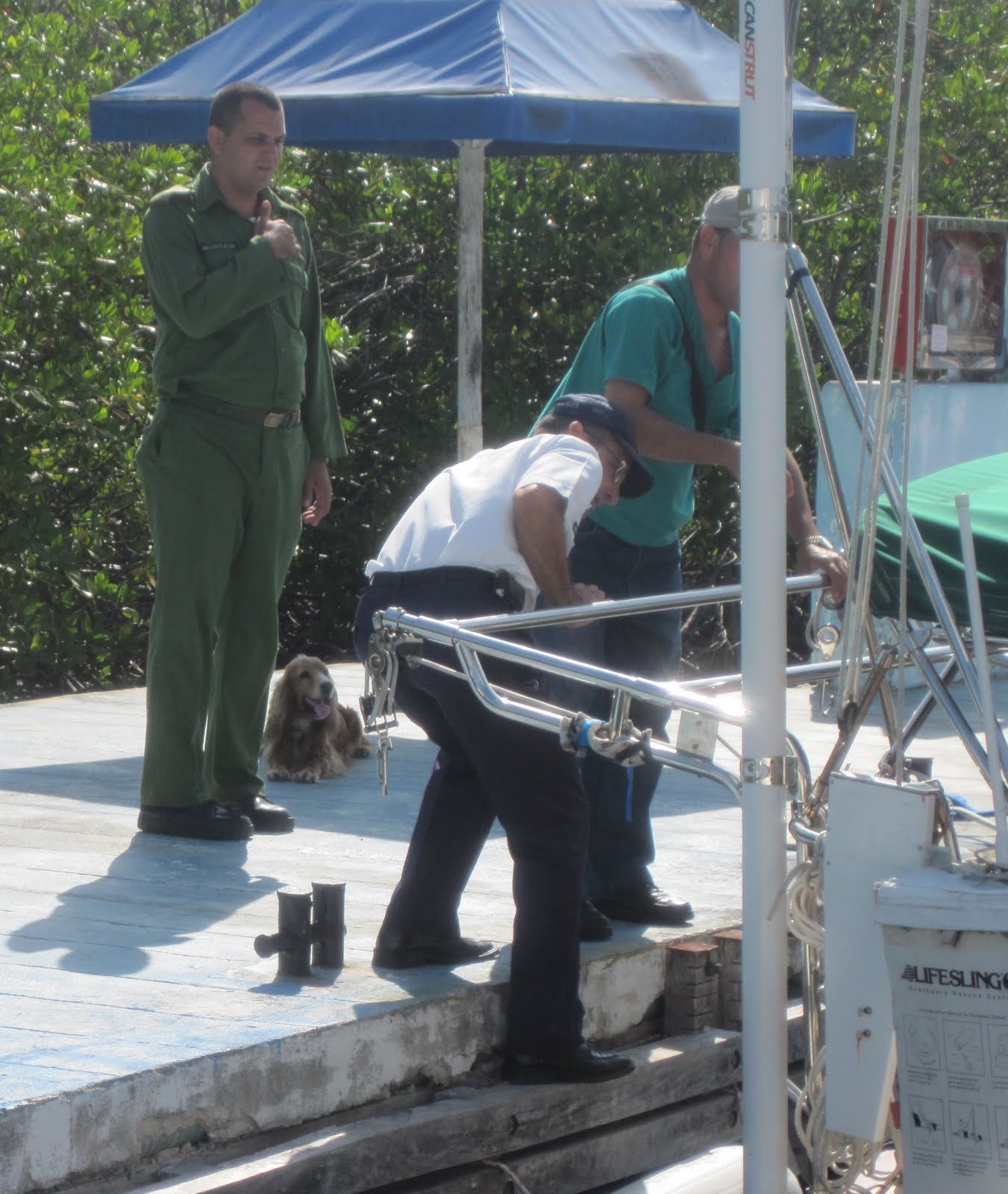
 A pretty spaniel and dog handler checked the boat for illegal substances. We had none. 
 
The Guarda Frontera was there for general security reasons. 

Puerto de Vita sees about 30 cruising boats each year. From March 23 to 25, eleven boats checked in.  It was a busy time for the officials and appears to be a sign of things to come as interest in Cuba increases among the cruising community. Everyone was extremely pleasant and accommodating and welcomed us to their country. By 1:30 in the afternoon the check in process was completed and Tina, the dock master, arranged for taxis to take us to the nearby resort town of Guardalavaca where we could go to the bank and change our money for Cuban convertible pesos to pay for our entry stamp ($20CUC) and veterinary inspection ($5CUC). Sometimes there is also a fee for the doctor’s visit but we were not charged.  Canadian cash is the best currency to take to Cuba. The exchange rate is slightly better than the US dollar and the 20% surcharge does not apply. Second best is a Canadian credit card. The transaction is processed in US dollars but without the surcharge. US credit cards are not accepted. 

 The batting cage across the street from the bank in Guardalavaca is evidence of Cuba’s passion for baseball.

Our first sighting of a Classic American automobile.

 Tourist trinkets.

 Tourist beach.

  Tourist beer

All inclusive resorts are not why we came to Cuba. Time for a road trip.


Thursday, May 12, 2011

Leaving Long Island and the Bahamas

Leaving Long Island and the Bahamas – March 13 to 22, 2011


When we first arrived in the settlement of Salt Pond on Thompson Bay our friends made arrangements to leave Long Island via Southern Air with a connecting flight to Nassau where they would catch a direct flight home at the end of their holiday. Sandra had done her homework back in Canada and knew that they could get a flight from Stella Maris Airport. She also knew that boats staying at the Stella Maris Marina have full access to the activities and amenities at the Stella Maris Resort and wanted to treat us to a couple of days in the marina. What she did not know is that the marina and the resort are on opposite sides of the island! Good for us that the amenities include shuttle service between the marina and the resort.


Southern Air flies from Stella Maris Airport


As we made our way north to the marina the fishing lines were in the water. Two hours after pulling up anchor at Thompson Bay, Tri landed this feisty fellow. As we do not eat barracuda, back in the water he went.


Not taking any chances, the freezer had been replenished with grouper and hog fish from a local fishing boat in Thompson Bay before we left. The second annual “Cooking with Tri” episode would go on as scheduled. We arrived at the marina after a beautiful sail in 14 knot winds and using eyeball navigation to find our way. The narrow dredged channel could be identified by the very slightly darker colour of the deeper water and the barely visible, thin poles topped with the remains of Styrofoam fishing floats. Oh yes, and don’t forget to keep those poles to port as you are going in.


Chivago, the nice young dock master at the marina, returned from lunch with the banana leaf that Tri needed to wrap dinner in. I guess we should have mentioned that how much we needed.


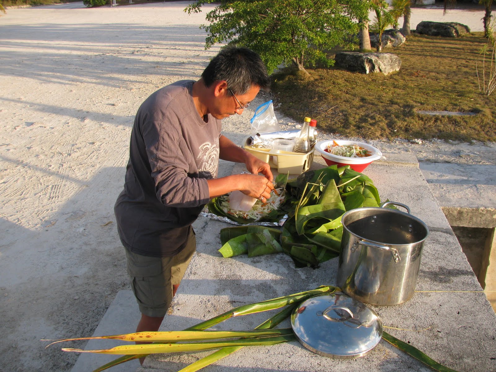
Hog fish encased in banana leaves with shredded cabbage, carrots, onions and a few other secret ingredients, then a wrapped in foil and baked on the BBQ.


Harvesting coconut water for sky juice – a Bahamian thirst quencher. Polar Pacer’s version: Mix a generous shot of gin with a glass of coconut water. Add a tablespoon or two of sweetened condensed milk and lots of ice. Stir and enjoy.


Charades? Waiting for the morning shuttle to take us to the resort.


It is not often that we play tourist and spend the day at a resort. In fact this was the one and only time since we started this adventure. What a treat. We signed up for the half day trip to Cape Santa Maria to go snorkeling and didn’t even have to take our own towels to use at the beach. There were fresh water showers and a swimming pool at our disposal. No tracking salt and sand back to the boat! The poolside restaurant where we had lunch has an awesome view of the Atlantic.


Sandra checks out the tidal pool.


Next stop – Africa.


Evening entertainment at the resort consisted of a free rum punch party with appetizers and Rake ‘n Scrape. . That’s my Bahamian Uncle Bud on the far left.


Chicken and ribs on the outdoor grill. We were also treated to a very delicious buffet meal in the dining room before summoning the shuttle to take us back to our beds on the other side of the island.


The sadness of having our friends leave for home was soon filled with the anticipation of our next big milestone – heading for Cuba. We made use of the laundry facilities across the road from the marina where the proprietor turned out to be a fellow postage stamp collector. Cynthia very generously offered me the duplicates from her collection and I promised to reciprocate when I returned to Canada. The next morning we said goodbye to Chivago and headed back to Thompson Bay where we expected to connect with other Cuba bound boats and would stock up on a few provisions. We had heard that food would be easy to access in Cuba but were not sure how long it would take us to get there.


We found two locations in Salt Pond where we could access wi-fi. We could not pick up either signal from the anchorage so we had to dinghy in to shore with our computers to check email, do banking, check the weather websites and all the other things that need to be done when you are suffering from web withdrawal. Island Breeze has a dinghy dock and is conveniently located across the road from a well stocked grocery store. Tryphena’s Club Thompson Bay is at the opposite end of the bay where you must take your dinghy in to the beach, tie it securely to tree to ensure that the tide does not take it away, and walk half a mile up a dusty hill. In both locations the service was free of charge.


We always felt welcome at Club Thompson Bay. Tryphena was always glad to see us and hoped that while we spread our laptops out on one of her tables and plugged in we might buy a cold Kalik or some of her delicious cracked conch. Let’s just say that the atmosphere at Island Breeze was not always as congenial.


The Royal Bahamian Police Band arrived in town the day before our planned departure. There were two performances to send us off in style.


The Marching Band paraded back and forth in front of the crowd on a short dead end road near the waters’ edge. The drummer on the right is wearing a real leopard skin.


The lead crooner from the Pop’s Band ‘wow’d the ladies with his vocal and dancing talents. Michael Buble beware!


The Long Island Breeze dinghy dock. A short walk to the park.


For my birthday this year I took a cruise. A self guided cruise in the southwestern Bahamas from Salt Pond, Long Island to a remote anchorage on the western side of Flamingo Cay in the chain of small uninhabited islands that make up the Jumento Cays. We made the trip with two other catamarans. This would be our staging ground for the crossing to Cuba.


Birthday girls. Julie and I share a birthday. After a long day on the water we were rewarded with a wonderful lamb chop dinner (Many thanks to Chi Chi Maru) and not one, but two birthday cakes. And a special thank you to Phil who sent me a birthday hug via single side band radio and to John who did the relay for him.


We sat out a day of rain squalls in the lee of Flamingo Cay before making our way south to Raccoon Cay where our NV charts were scrutinized for hazards, the back-up navigation system of laptop and Garmin GPS combination was made ready and the required waypoints were double checked. In order to make landfall in Cuba during daylight hours we needed to leave Raccoon Cay in the wee hours of the morning.


The Jumentos Cays are frequented by Bahamian fishing boats looking to fill their holds before heading back to their home ports. We were able to stock up on hogfish and fresh lobster.

Thursday, April 28, 2011

More Company

More Company – March 6 to 12, 2011


With the engine repairs we were ready for the arrival of our next set of guests. Tri and Sandra, a.k.a. Chi Chi Maru, arrived in Georgetown just in time to get a taste of the Cruisers’ Regatta. The much hailed Cruisers vs. Bahamians ball game was scheduled for the night of their arrival. The ball diamond, complete with an official electronic scoreboard and a local play by play announcer, is a short walk from the dinghy dock at Lake Victoria and we were anchored nearby in Kidd Cove. Beer and burgers were on the menu at the ball field. What were we waiting for?

Is it any wonder that within minutes of the first pitch the score was slanted heavily in favor of the home team? The Bahamian team looked like they had practiced together a few times – the cruisers did not.

 Play by play.

We were ready to say goodbye to Georgetown and the next morning conditions were favorable to head eastward across the bottom of the Exuma Sound to Long Island. We had not previously visited Long Island so it would be a new adventure for us as well as our guests. Since the route from Georgetown to Cape Santa Maria on the northern end of Long island takes you over some reportedly good fishing grounds all possible fishing gear on board was put to work. That included three rigged ballyhoo bait that had been purchased from Exuma Markets and stored in the freezer. Although I was happy to see them gone from the freezer they did not produce the desired results. When the lines were finally pulled in on our approach to Calabash Bay we had not had even one bite!

After checking out a few anchoring options in Calabash Bay we opted for the narrow channel at Joe’s Sound to spend the night. The man made entrance is barely wider than Polar Pacer with hard rocky ledges just below the surface on either side.

Edgar, from Way Point came out in his dingy to guide us in. Once we were safely past the dangerous rocks we made a left turn and a small, spotted eagle ray took over and led us down the channel to our the spot where we dropped anchor.

When the tide goes out, an amazing expanse of beautiful, untouched white beach appears just a short swim away from the boat. With each turn of the tide all our footprints are washed away and it seems like we are seeing it for the first time all over again. We liked it so much we stayed for three days.

Enjoying the sun on Long Island.

As we made our way from Joe’s Sound to Thompson Bay we lost use of the chart plotter for the last time. Up until then we had been able to get it to read the chart card we were using for the Bahamas if we used a random combination of removing and re-inserting the card multiple times, turning the power switch to the unit off and on again (Sound like familiar advice from an IT Help Desk?) and doing the same with the main breaker to electrical panel. Not this time. Fortunately, Tom and Tri had a back-up plan in place. Using charts loaded on a lap top and a portable GPS unit we were still able to chart a safe course to follow our course. Using waypoints entered on the very basic ‘world chart’ on the plotter we were still able to use the auto pilot for steering. Not quite as convenient as having everything integrated but doable when used in conjunction with the paper charts.

At Salt Pond, the settlement on Thompson Bay, we picked up a rental car from Fox’s Autos to tour the island. Queens Highway runs from one end of the island to the other with a few, mostly unpaved roads branching off on either side. Salt Pond sits roughly at the mid-point. Our mission was to tour the southern half of the island on the first day and the northern half on the second.

A not so subtle reminder that in the Bahamas you need to drive on the right side of the road.

 Clarence Town is home to two landmarks; St. Paul’s Anglican Church dating back to 1848 and the relatively newer St. Peter’s Catholic Church. Both were built by the same man, John Cecil Hawes (a.k.a. Father Jerome) during different periods of his religious affiliation.

 Several abandoned salt ponds are visible from Queens Highway. All that remains from their productive days are the stone walls laid out in a grid pattern.

 The road to the beach at yet another unfinished Bahamian real estate development.

 Grounded and now a building site for ospreys.

Dean’s Blue Hole is a popular stop for divers. At a depth of 663 feet it claims to be the deepest blue hole in the world. A warning sign posted nearby advises that less than competent swimmers should not venture near or in the hole. We steered clear. Besides, we did not want to spend the rest of the day in salty clothing.

 No visit from Chi Chi Maru would be complete without Tri foraging for items that he could use to cook a gourmet meal on board. Here he searches for tamarind pods mature enough to pick while Tom and Sandra enjoy refreshments at the Max Conch Bar.

In the small convenience store next door to the conch bar we met an elderly resident who told us about growing up in a neighboring settlement and moving to her current home when she married in 1942. She has lived in the same house ever since. She talked about traveling to Nassau from Long Island by primitive sailboat in the early days, a trip that could take several days, and the transition from sail to different level of power boats. Now there is an airport just a few minutes away and when she goes to visit her family in Nassau she flies there in less than an hour.

On the second and last Saturdays of each month there is a small farmer’s market in Salt Pond. We were running low on fresh fruit and veggies and since we had the rental car it was an opportunity to stock up. Opportunities with transportation should never be passed up.

 
There were about half a dozen vendors at the market. The typical offerings were papaya, bananas, sweet potatoes, onions, cabbage and sugar cane. Not a wide selection but fresher than anything we were likely to find in the local grocery stores.

Day two of our Long Island road trip took us to the northernmost tip of the island, Cape Santa Maria, the location of the Columbus Monument.

Erected on the high cliffs overlooking Exuma Sound, the monument is dedicated to the Lucayans, “The gentle, peaceful and happy aboriginal people of Long Island and the arrival of Christopher Columbus on October 17th, 1492.” 

The road to the monument is little more than a long rocky, non-maintained trail almost overgrown by buttonwood and other small shrubs. We got a surprised reaction from the locals when we told them we made the trip in a rental car.

The view was worth the bumpy ride. 

 Other highlights to our northern tour were the beach bar at Deals where we watched television coverage of the earthquake and nuclear plant disaster in Japan, 

the tiny Stella Maris airport where we met Stella napping in the sun, 

the cave at the Stella Maris Resort where night time parties with the bats are hosted for guests.

and the rock formations created by the ocean on the eastern side of the island directly across from Salt Pond.

The Joy of Hauling

The Joy of Hauling – February 20 to March 5, 2011


We have often read that the definition of cruising is “fixing boats in exotic places”. The first year we were out everything was new and worked perfectly. This year is another story. Things are starting to wear out. As much as we try to keep up with the preventive maintenance, there are things that just go wrong sometimes.

At 5:30 sharp Elvis arrived with his water taxi to take our guests back across the harbour in the dark where they would share a taxi to the airport for their flight home. We began preparations to deal with our water pump and drive leg issues.

Masters Harbour Marina, formerly known as George Town Marina and still displaying a sign as such, is located south of town in an area commonly referred to as Red Shanks. It has a travel lift (the only one we know of in the Exumas) capable of hauling Polar Pacer. Arrangements were made with Nockey to be lifted out of the water and dropped on dry land for a day. We may have been able to beach her on a sand bar at low tide to do the job but did not want to risk having complications.

The route in to Masters Harbour is scattered with shallow coral heads. Dave, from Texas Two Step, met us in his dinghy as we made our way in and joined us on board to help “read the water”. The coral heads were surprisingly easy to indentify. They appear as a very dark patches surrounded by a ring of white sand. Once they were located it was a matter of weaving a path between them Tom set a track on the chart plotter as we went so we could follow the same route on the way back out.

 Steer clear of the dark spots.

 The Masters Harbour lift.

 On the hard in an exotic place?

Dave generously offered to help out with the dismantling and rebuilding of the drive leg. It is always nice to have an extra set of knowledgeable hands and moral support at times like this – even more so when a broken c-clip appears and you are not able to identify where it came from!

Thanks for being there for us, Dave.

With the removal of the upper part of the drive leg the original home of the errant c-clip was located. The next hard part was to find a replacement for it. Cookie Monster and Tortuga to the rescue! Corbett and Bill took a long dinghy ride from Volleyball Beach to the NAPA store at Goat Cay, north of Georgetown, to see if they could find something that would work. They then took an even longer dinghy ride from Goat Cay to Masters Harbour to tell us that yes, they found the part and to help put the drive leg back together. The part arrived by car later that afternoon. I won’t embarrass anyone by explaining why they had to come by car. The reassembly process was quick and easy with help from Corbett and Bill.

Thank guys, for all your help and for adding a bit of humour to an otherwise unpleasant situation.

By evening everything was back together with the drive leg filled with fresh fluid and we were ready to go back in the water first thing in the morning. A small added bonus was hot showers (boatyard style) and an unsecured wi-fi signal.

Next on the repair agenda was replacing the water pump. Returning to crowded Georgetown (the boat count in the harbour was nearing 300) while we waited for a new pump did not appeal to us. As we were not far from the Red Shanks anchorages it made sense to tuck in among the low, rock islands for a few days. There were only five other boats in sight – just enough for a pot luck party when the tide went out and exposed a small sandy beach. Robin’s cherry pie cooked over the open fire was a real hit.

The swimming pool at Red Shanks.

As I snorkeled around the boat one afternoon I crossed paths with a large southern stingray that. From my perspective it looked to be about six feet across but then everything looks larger in the water. When it sensed my presence it settled on the sandy bottom until I swam by. I did not linger.

The small boat route between Crab Cay and the main island of Great Exuma from Red Shanks to Georgetown is preferable for a dinghy trip to pick up supplies or go in to J&K to use the internet. Besides being more protected in unsettled weather, it is more scenic. The route passes over a deep blue hole and under an extravagant bridge that joins the two islands. Our 2006 Explorer chart book contains a full page ad for the Crab Cay Resort showing a marina with 100 feet of floating docks, a spa, a restaurant, botanical gardens and dozens of villas.


The only part that has been completed is this bridge.

The development has been abandoned for several years, the stacks of construction materials and idle equipment being the only evidence of someone’s dream.

In researching the never ending overheating issue that was getting steadily worse Tom determined that it was probably a faulty water pump. This was confirmed when we started experiencing increased difficulty in getting good water flow when we started the engine. When we had our new (2009) Yanmar YM30 serviced back in the boatyard in Deltaville the original water pump was rebuilt. Apparently those pumps are not re-buildable and it should have been replaced. An order was placed with JAS Marine in Florida for a replacement pump plus a spare. Forbes Enterprises in Georgetown recommended that we use Bimini Shipping out of Ft. Lauderdale who would bring the package directly to Georgetown without having to go through Nassau. Forbes could act as our broker and there should be no import duties to pay as the parts were necessary for the operation of a vessel in transit. Everything seemed to be in order and it looked like we would receive the new pumps by the end of the following week. When Tom checked the status of the shipment on the day the freighter was to leave the US he was told that they had been unable to put the package on the ship as they did not have a copy of the invoice stating the value of the contents! They needed written permission to open the package and look at the invoice inside. Tom sent the appropriate email but by then it was too late to make that week’s sailing. After the horror stories we had heard from other cruisers trying to get parts brought in to the Bahamas from the US we were not entirely surprised at the delay but still disappointed that things did not happen as planned. Once the package did arrive it was only a matter of minutes until the new one was installed and we were back in business with a properly working engine. At the time of this post, about 6 weeks and many hours of motoring later, I am pleased to report that we have not overheated once!

 Out with the old and in with the new.

Oh, have I mentioned that our Raymarine chart plotter has stopped reading charts? While we were waiting for things to happen with our other repairs Tom took the opportunity to start planning for our upcoming trip to Cuba at the end of March. Lo and behold when he removed the electronic chart chip we had been using for the Bahamas and put in the one that we would be using for Cuba it would not display the detailed charts consistently. After much experimenting with other chart chips and discussion with other cruisers and the Raymarine help desk it was determined that the plotter will need to be returned to the manufacturer for repair. Something else to be added to the ‘to do’ list.